Cricqueville-en-Bessin
You can help expand this article with text translated from the corresponding article in French. (December 2008) Click [show] for important translation instructions.
|
Cricqueville-en-Bessin | |
|---|---|
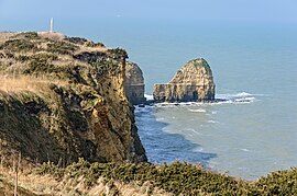
 La Pointe du Hoc | |
| Coordinates: 49°22′38″N 1°00′01″W / 49.3771°N 1.0002°W | |
| Country | France |
| Region | Normandy |
| Department | Calvados |
| Arrondissement | Bayeux |
| Canton | Trévières |
| Intercommunality | CC Isigny-Omaha Intercom |
| Government | |
| • Mayor (2022–2026) | Pascale Vibet[1] |
Area 1 | 8.55 km2 (3.30 sq mi) |
| Population (2022)[2] | 170 |
| • Density | 20/km2 (51/sq mi) |
| Time zone | UTC+01:00 (CET) |
| • Summer (DST) | UTC+02:00 (CEST) |
| INSEE/Postal code | 14204 /14450 |
| Elevation | 0–39 m (0–128 ft) (avg. 50 m or 160 ft) |
| 1 French Land Register data, which excludes lakes, ponds, glaciers > 1 km2 (0.386 sq mi or 247 acres) and river estuaries. | |
Cricqueville-en-Bessin (French pronunciation: [kʁikvil ɑ̃ bɛsɛ̃] ⓘ, literally Cricqueville in Bessin) is a commune in the Calvados department in the Normandy region in northwestern France.
The municipality takes its name from its deep-water creek that forms a natural harbor, from Crycavilla.
History
[edit]World War II
[edit]Just outside Cricqueville, the United States Army Air Forces established an airfield shortly after D-Day on 9 June 1944, just three days after the Allied landings in France. The airfield was one of the first established in the liberated area of Normandy. Known as Advanced Landing Ground "A-2" (Cricqueville), it was used from early June though September 1944. After the Americans moved east into Central France, the airfield was dismantled and the land returned to agricultural use.[3][4]
Population
[edit]| Year | Pop. | ±% |
|---|---|---|
| 1962 | 197 | — |
| 1968 | 200 | +1.5% |
| 1975 | 190 | −5.0% |
| 1982 | 157 | −17.4% |
| 1990 | 171 | +8.9% |
| 1999 | 182 | +6.4% |
| 2008 | 186 | +2.2% |
See also
[edit]- Communes of the Calvados department
- Pointe du Hoc, a point of attack by the United States Army during the Battle of Normandy
References
[edit]- ^ "Répertoire national des élus: les maires" (in French). data.gouv.fr, Plateforme ouverte des données publiques françaises. 6 June 2023.
- ^ (in French). The National Institute of Statistics and Economic Studies. 19 December 2024 https://www.insee.fr/fr/statistiques/8288323?geo=COM-14204.
{{cite web}}: Missing or empty|title=(help) - ^ AAF Airfields in France, Belgium, Netherlands, Luxembourg Archived January 6, 2009, at the Wayback Machine
- ^ Air Force History Index


